For Immediate Release
September 30, 2010
Flood Condition Plans
Thursday, September 30, 2010
In the event that a weather emergency is declared due to flood conditions throughout the city, Police Department personnel will be deployed to the following locations to implement street closures as the need arises:
Columbus Boulevard
Kelly Drive
Lincoln Drive
Martin Luther King Drive
Main Street in Manayunk
Roosevelt Boulevard
Cobbs Creek Parkway
Although the aforementioned locations are typical hotspots for flooding conditions and downed trees, there is the possibility that many other areas will be affected by flooding and high-winds as well. Thank you for your cooperation during this possible weather emergency.
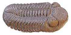
Phacops Rana
Thursday, September 30, 2010

Flood warning and tornado watch this afternoon and evening
Philadelphia is under a flood warning and a tornado watch until 7:45 this evening (Thursday) as remnants of tropical storm Nicole and a large low have merged and are moving northeastward up the coast. Heavy rains associated with this huge storm have caused flooding to our south.
Flood watch continued into Friday
What was Tropical Storm Nicole was absorbed into a low pressure trough along the Mid-Atlantic seaboard and was causing heavy rain in North Carolina on Thursday morning. The trough will continue to move through the region into Friday as moisture to the south moves northward. The flood watch for this area continues into Friday. Flood warnings were posted to the west this morning. A flood warning means that flooding is either imminent or occuring.
Wednesday, September 29, 2010
Area under flood watch until Thursday night
The National Weather Service has issued a flood watch for Philadelphia and the region. The flood watch extends until Thursday night.
According to the National Weather Service, low pressure associated with Tropical Storm Nicole will move up the East Coast tonight and Thursday. With extremely high moisture content... a strong storm inflow... and lots of instability... rain beginning tonight will be heavy at times later tonight and especially Thursday. The rain should taper off Thursday night as the center of tropical low pressure moves north of our area.
Total precipitation is expected to average 2 to 4 inches... but local amounts may be up to 6 or 7 inches. Although the forecast could change... at this time the greatest precipitation is expected over the northeast Maryland shore... eastern Pennsylvania... Delaware... and western New Jersey. Slightly lesser although still heavy amounts may occur closer to the New Jersey coast.
According to the National Weather Service, low pressure associated with Tropical Storm Nicole will move up the East Coast tonight and Thursday. With extremely high moisture content... a strong storm inflow... and lots of instability... rain beginning tonight will be heavy at times later tonight and especially Thursday. The rain should taper off Thursday night as the center of tropical low pressure moves north of our area.
Total precipitation is expected to average 2 to 4 inches... but local amounts may be up to 6 or 7 inches. Although the forecast could change... at this time the greatest precipitation is expected over the northeast Maryland shore... eastern Pennsylvania... Delaware... and western New Jersey. Slightly lesser although still heavy amounts may occur closer to the New Jersey coast.
Tuesday, September 28, 2010
Tornado watch this afternoon
The region is under a tornado watch until 6 p.m. Tuesday. The National Weather Service reminds that a tornado watch means that a tornado is possible. If signs that a tornado is forming NWS will issue a tornado warning. However, there may not be sufficient time if a tornado develops rapidly.
Storms associated with the passage of a cold front result from unstable air, conditions that are favorable for tornado development.
Storms associated with the passage of a cold front result from unstable air, conditions that are favorable for tornado development.
New tropical storm threatens Cuba, U.S. East Coast
Tropical Depression 16 is approaching Cuba on Tuesday afternoon. The National Hurricane Center expects the storm to strengthen into a tropical storm. It would weakend somewhat over Cuba, but will emerge and pass up the eastern coast of Florida, then head toward the South Carolina-North Carolina state line by Thursday morning, according to NHC predictions. strengthening in the Atlantic is likely.
Wednesday, September 22, 2010
Dynamics of the Planet
Adventures on Earth column for the September 22 edition of The Review
Some of the oldest rock on Earth can be found in what is called the Canadian Shield, a circular shaped belt of rock running from Greenland down to the northeastern US border, and then westward over the Canadian prairie, then up to the Arctic Ocean.
Most of the rock in the formation was laid down from 2.45 to 1.24 billion years ago.
It is the foundation upon which the rest of North America was built. Unlike parts of the United States, the Canadian Shield never was covered by sea.
In two places the Shield dips just a bit into the United States: the Upper Peninsula of Michigan and the Adirondack Mountains. It is the Adirondack Mountain section that we will examine here.
The Adirondack Mountains of New York State are unique among American mountain chains. American mountains are generally uplifted as the result of collision of continental land masses.
The folding and faulting of mountains results from lateral compression when two land masses are pushed together.
The rocks of the Canadian Shield were formed this way in what was known as the Grenville Orogeny. An orogeny is a pulse of mountain building that takes place when continents collide.
The Grenville Orogeny brought the Canadian Shield together with what are now parts of Europe into a supercontinent that geologists call Rodinia. Rodinia eventually broke up, but then the continents came together again during the Alleghenian Orogeny that formed the supercontinent called Pangea. Pangea, in turn, broke up to form the present array of continents and islands.
After the break-up of Rodinia, the Adirondacks eroded away into an elevated plain (called a penneplain) like the rest of the Canadian Shield. Unlike the rest of the Shield, the Adirondacks were submerged under a sea. Sediments covered the Shield rock.
During the Tertiary, which began 65 million years ago until 1.6 million years ago, the Adirondacks began to rise. Geologists think a hot spot developed in the mantle below the continental rock.
Hot spots are upwellings of the viscous mantle rock. Hawaii and Yellowstone are two places located over hot spots. As ocean or continental plate moves over a hot spot, volcanoes form. As the plate moves, the hot spot remains fixed.
A hot spot under the Adirondacks would seem to be fairly new by geologic standards. Hot spots usually form a chain of volcanoes or scars on the land. There is no such chain for the Adirondacks.
The mountains continue to rise at the rate of 2-3 millimeters a year, very rapid by geologic standards.
What does this mean for the future? The Adirondacks will continue to rise, although the rate will vary, for some time to come.
What could happen next, as the mountains rise, is that the rock will stretch. At some point it will break, forming the beginnings of a rift valley. Parts of North America will drift apart as the sea spreads into the rift valley.
None of us will be around to witness the process, but eventually land masses will again begin to move together. That process is the dynamics of the planet.
Some of the oldest rock on Earth can be found in what is called the Canadian Shield, a circular shaped belt of rock running from Greenland down to the northeastern US border, and then westward over the Canadian prairie, then up to the Arctic Ocean.
Most of the rock in the formation was laid down from 2.45 to 1.24 billion years ago.
It is the foundation upon which the rest of North America was built. Unlike parts of the United States, the Canadian Shield never was covered by sea.
In two places the Shield dips just a bit into the United States: the Upper Peninsula of Michigan and the Adirondack Mountains. It is the Adirondack Mountain section that we will examine here.
The Adirondack Mountains of New York State are unique among American mountain chains. American mountains are generally uplifted as the result of collision of continental land masses.
The folding and faulting of mountains results from lateral compression when two land masses are pushed together.
The rocks of the Canadian Shield were formed this way in what was known as the Grenville Orogeny. An orogeny is a pulse of mountain building that takes place when continents collide.
The Grenville Orogeny brought the Canadian Shield together with what are now parts of Europe into a supercontinent that geologists call Rodinia. Rodinia eventually broke up, but then the continents came together again during the Alleghenian Orogeny that formed the supercontinent called Pangea. Pangea, in turn, broke up to form the present array of continents and islands.
After the break-up of Rodinia, the Adirondacks eroded away into an elevated plain (called a penneplain) like the rest of the Canadian Shield. Unlike the rest of the Shield, the Adirondacks were submerged under a sea. Sediments covered the Shield rock.
During the Tertiary, which began 65 million years ago until 1.6 million years ago, the Adirondacks began to rise. Geologists think a hot spot developed in the mantle below the continental rock.
Hot spots are upwellings of the viscous mantle rock. Hawaii and Yellowstone are two places located over hot spots. As ocean or continental plate moves over a hot spot, volcanoes form. As the plate moves, the hot spot remains fixed.
A hot spot under the Adirondacks would seem to be fairly new by geologic standards. Hot spots usually form a chain of volcanoes or scars on the land. There is no such chain for the Adirondacks.
The mountains continue to rise at the rate of 2-3 millimeters a year, very rapid by geologic standards.
What does this mean for the future? The Adirondacks will continue to rise, although the rate will vary, for some time to come.
What could happen next, as the mountains rise, is that the rock will stretch. At some point it will break, forming the beginnings of a rift valley. Parts of North America will drift apart as the sea spreads into the rift valley.
None of us will be around to witness the process, but eventually land masses will again begin to move together. That process is the dynamics of the planet.
Subscribe to:
Posts (Atom)